![](/images/other/stat-length.png)
![Trail Walking Le Valtin - Vosges - Sentier des roches - Photo](https://media.geolcdn.com/t/1900/400/ext.pjpeg?maxdim=2&url=https%3A%2F%2Fstatic1.geolcdn.com%2Fsiteimages%2Fupload%2Ffiles%2F1553511878bg_sport_marche.png)
Vosges - Sentier des roches
© OpenStreetMap contributors
![Walking](https://static1.geolcdn.com/sitytour/trail-icons/101.png)
Walking
--
Difficulty : Medium
![Length](/images/other/stat-length.png)
Length
15.2 km
![Max alt](https://static1.geolcdn.com/siteimages/upload/files/1508320355ic_sort_altitude_max_24dp.png)
Max alt
1310 m
![Uphill gradient](https://static1.geolcdn.com/siteimages/upload/files/1508320355ic_sort_den_pos_24dp.png)
Uphill gradient
896 m
![Km-Effort](/images/other/stat-length.png)
Km-Effort
27 km
![Min alt](https://static1.geolcdn.com/siteimages/upload/files/1508320355ic_sort_altitude_min_24dp.png)
Min alt
922 m
![Downhill gradient](https://static1.geolcdn.com/siteimages/upload/files/1508320355ic_sort_den_neg_24dp.png)
Downhill gradient
903 m
![Boucle](https://static1.geolcdn.com/siteimages/upload/files/16400158638029165_repeat_loop_refresh_sync_direction_icon.png)
Boucle
Yes
Creation date :
2014-12-10 00:00:00.0
Updated on :
2014-12-10 00:00:00.0
![Walking](https://static1.geolcdn.com/sitytour/trail-icons/101.png)
--
Difficulty : Medium
![Scan this QR Code to open this trail in the SityTrail application](https://capi.geolives.com/qq0zvz2zws4bq2lad0pu/sitytour/trails/129293/qr.png?size=200)
FREE GPS app for hiking
About
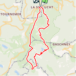
Trail Walking of 15.2 km to be discovered at Grand Est, Vosges, Le Valtin. This trail is proposed by aurianlecomte@hotmail.com.
Description
Sentier des roches - col entre les honeck - lac de Schiessrothried - Kastelberg - le honeck - Col de Falimont - col de la Schlucht
Physique (/10) : 6
Technique (/10) : 8
Positioning
Country:
France
Region :
Grand Est
Department/Province :
Vosges
Municipality :
Le Valtin
Location:
Unknown
Start:(Dec)
Start:(UTM)
352683 ; 5325255 (32U) N.
Comments
Trails nearby
![Trail Walking Le Valtin - Les Rochers des Hirschsteine - Lac Vert - Photo](https://media.geolcdn.com/t/375/260/4177d9e5-d8bc-4dac-ac45-c42f01ca30d3.jpg&format=jpg&maxdim=2)
![Walking Walking](https://static1.geolcdn.com/sitytour/trail-icons/101.png)
Les Rochers des Hirschsteine - Lac Vert
Walking
Difficult
(2)
Le Valtin,
Grand Est,
Vosges,
France
![](/images/other/stat-length.png)
14.4 km | 22 km-effort
5h 2min
![](https://static1.geolcdn.com/siteimages/upload/files/16400158638029165_repeat_loop_refresh_sync_direction_icon.png)
Yes
![Trail Walking Le Valtin - Col de la Schlucht - Photo](https://media.geolcdn.com/t/375/260/5b598871-c43c-4378-92fe-f06bddb4af29.jpg&format=jpg&maxdim=2)
![Walking Walking](https://static1.geolcdn.com/sitytour/trail-icons/101.png)
Col de la Schlucht
Walking
Very easy
(1)
Le Valtin,
Grand Est,
Vosges,
France
![](/images/other/stat-length.png)
3.5 km | 5.2 km-effort
1h 17min
![](https://static1.geolcdn.com/siteimages/upload/files/16400158638029165_repeat_loop_refresh_sync_direction_icon.png)
Yes
![Trail Walking Le Valtin - Le Sentier des Roches - Photo](https://media.geolcdn.com/t/375/260/f2737479-0e9e-43ec-9b66-c9706dc8ef91.jpg&format=jpg&maxdim=2)
![Walking Walking](https://static1.geolcdn.com/sitytour/trail-icons/101.png)
Le Sentier des Roches
Walking
Difficult
(2)
Le Valtin,
Grand Est,
Vosges,
France
![](/images/other/stat-length.png)
20 km | 34 km-effort
7h 43min
![](https://static1.geolcdn.com/siteimages/upload/files/16400158638029165_repeat_loop_refresh_sync_direction_icon.png)
Yes
![Trail Walking Stosswihr - Tour du belvedere avec le passage sur les crêtes - Photo](https://media.geolcdn.com/t/375/260/5b3c85c1-2643-45e9-9769-80e100e05dda.jpg&format=jpg&maxdim=2)
![Walking Walking](https://static1.geolcdn.com/sitytour/trail-icons/101.png)
Tour du belvedere avec le passage sur les crêtes
Walking
Very easy
(3)
Stosswihr,
Grand Est,
Haut-Rhin,
France
![](/images/other/stat-length.png)
8.5 km | 0 m-effort
2h 28min
![](https://static1.geolcdn.com/siteimages/upload/files/16400158638029165_repeat_loop_refresh_sync_direction_icon.png)
Yes
![Trail Other activity Soultzeren - Totom 4 lacs - Photo](https://media.geolcdn.com/t/375/260/ext.jpg?maxdim=2&url=https%3A%2F%2Fservices.sitytrail.com%2FGeolivesWS%2FDownloadMedia.ashx%3FTrailID%3D789048%26Media%3D20170713134427.jpg)
![Other activity Other activity](https://static1.geolcdn.com/sitytour/trail-icons/900.png)
Totom 4 lacs
Other activity
Medium
(1)
Soultzeren,
Grand Est,
Haut-Rhin,
France
![](/images/other/stat-length.png)
15.6 km | 26 km-effort
4h 37min
![](https://static1.geolcdn.com/siteimages/upload/files/16400158638029165_repeat_loop_refresh_sync_direction_icon.png)
Yes
![Walking Walking](https://static1.geolcdn.com/sitytour/trail-icons/101.png)
Les 5 lacs autour du Hohneck
Walking
Very difficult
(1)
La Bresse,
Grand Est,
Vosges,
France
![](/images/other/stat-length.png)
21 km | 36 km-effort
7h 21min
![](https://static1.geolcdn.com/siteimages/upload/files/16400158638029165_repeat_loop_refresh_sync_direction_icon.png)
Yes
![Trail Walking Le Valtin - Les Hirschsteine - Photo](https://media.geolcdn.com/t/375/260/ext.jpg?maxdim=2&url=https%3A%2F%2Fservices.sitytrail.com%2FGeolivesWS%2FDownloadMedia.ashx%3FTrailID%3D311037%26Media%3Dfix__20140608114301.jpg)
![Walking Walking](https://static1.geolcdn.com/sitytour/trail-icons/101.png)
Les Hirschsteine
Walking
Difficult
(1)
Le Valtin,
Grand Est,
Vosges,
France
![](/images/other/stat-length.png)
16.1 km | 25 km-effort
6h 28min
![](https://static1.geolcdn.com/siteimages/upload/files/16400158638029165_repeat_loop_refresh_sync_direction_icon.png)
Yes
![Trail Walking Ban-sur-Meurthe-Clefcy - La vallée de Belbriette - Ban-sur-Meurthe-Clefcy - Photo](https://media.geolcdn.com/t/375/260/ext.jpg?maxdim=2&url=https%3A%2F%2Fservices.sitytrail.com%2FGeolivesWS%2FDownloadMedia.ashx%3FTrailID%3D172951%26Media%3D14431_5.jpg)
![Walking Walking](https://static1.geolcdn.com/sitytour/trail-icons/101.png)
La vallée de Belbriette - Ban-sur-Meurthe-Clefcy
Walking
Medium
(2)
Ban-sur-Meurthe-Clefcy,
Grand Est,
Vosges,
France
![](/images/other/stat-length.png)
9.8 km | 12.6 km-effort
2h 30min
![](https://static1.geolcdn.com/siteimages/upload/files/16400158638029165_repeat_loop_refresh_sync_direction_icon.png)
Yes
![Trail Walking La Bresse - Du Hohneck au Kastelberg par les Spietzkoepfe et le Sentier des Névées - Photo](https://media.geolcdn.com/t/375/260/ext.jpg?maxdim=2&url=https%3A%2F%2Fservices.sitytrail.com%2FGeolivesWS%2FDownloadMedia.ashx%3FTrailID%3D110319%26Media%3D5746_5.jpg)
![Walking Walking](https://static1.geolcdn.com/sitytour/trail-icons/101.png)
Du Hohneck au Kastelberg par les Spietzkoepfe et le Sentier des Névées
Walking
Very difficult
(3)
La Bresse,
Grand Est,
Vosges,
France
![](/images/other/stat-length.png)
7.6 km | 13.7 km-effort
3h 30min
![](https://static1.geolcdn.com/siteimages/upload/files/16400158638029165_repeat_loop_refresh_sync_direction_icon.png)
Yes
très belle, très variée, passages difficiles à ne pas privilégier avec des enfants de moins de 10/12 ans
Belle ballade. Difficile pour randonneur en bonne forme physique. Passages de pierriers délicats après le lac du Schiesrothried. Distance sous-évaluée : 23 km au GPS. A ne faire que par grand beau temps. Repas sympathique à la ferme-auberge du Schiesroth.